 |
| beaten silly by the East Fork of the Jarbidge |
The Uintas came up a time or three because of the ease of getting there. The lazy access, along with it being the 24th of July made for a quick ditching of that plan. The difficult access of the Jarbidge Wilderness in Northeast Nevada has posted it's position a long tenure on our list. Each year, we've had an excuse, despite knowing the brevity of the season that The Jarbidge is do-able. We overlooked the price of gas momentarily enough to roll into the setting sun, on the eve of the 24th just as barricades were going up for the gentiles to celebrate their independence, from what I've yet to determine.
I wanted to go to the Jarbidge because of the remote location, difficult access, and guarantees of solitude, plus the name sounded cool. Later I found out the name means something about a rabid beast. Apparently the savages of centuries gone by chased the beast into a cave where they cornered, then walled him in, where he's been ever since....deep in the Jarbidge Wilderness.
The old '77 performed it's duty of getting us to "remote" with nostalgic expense.
The difficulty of access came with each inch of the Jarbidge, every day, for hours on end.
After the first couple miles we saw no one for the next four days and 36 miles.
Our looping route; 4 days and 36 miles through the Jarbidge, was completely arbitrary. We looked at a 1:75,000 scale FS trail map and the route was plenty obvious.

I tried looking some stuff up online, but found nothing useful for our purpose. So we went and started walking.
Day 1, (~6.5 miles)
Tr105 Jarbidge R. TH to Jarbidge L.
We finished the drive north from Deeth to Jarbidge. Didn't go into town, but straight to the trailhead on a road that justified taking the blazer. It crossed the Jarbidge River a couple times, was pretty rough, and was just long enough that it would've sucked to walk that extra distance at trips end. We spread our shit out on a tarp and organized the junk pile that was thrown into the back of the blazer when we left SLC the night before. A couple drove by us on an ATV, turned around at the wilderness boundary trailhead, and went back the way they came. They looked like that's about as close as they dare get to a Wilderness certain to terrorize their metabolism. We shrugged and continued packing for 5 days on foot.
It was nice to finally be walking after the long drive. We made it to the first trail junction and took a break, then started the steep ascent to Jarbidge Lake where we'd camp the first night. Although the Jarbidge isn't big on lakes like some other wilderness areas are, I thought Jarbidge was a fine little lake. It had high peaks stretching into the backdrop, and the water was surrounded by green grass and blue bells so thick it was hard to not step on them.

 |
| High peaks of the Jarbidge beyond Jarbidge Lake |

 |
| Camp 1; Alpenglow |
Day 2 (~15.5 miles)
Tr105 Jarbidge L. to Emerald L.
Tr020 Emerald L. to E. Fork Jarbidge R.
Tr200 E. Fk. Jarbidge R. to Camp Ck. Pass
Tr099 Camp Ck. Pass to Camp Ck.
Tr195 Camp Ck. to Marys River Basin
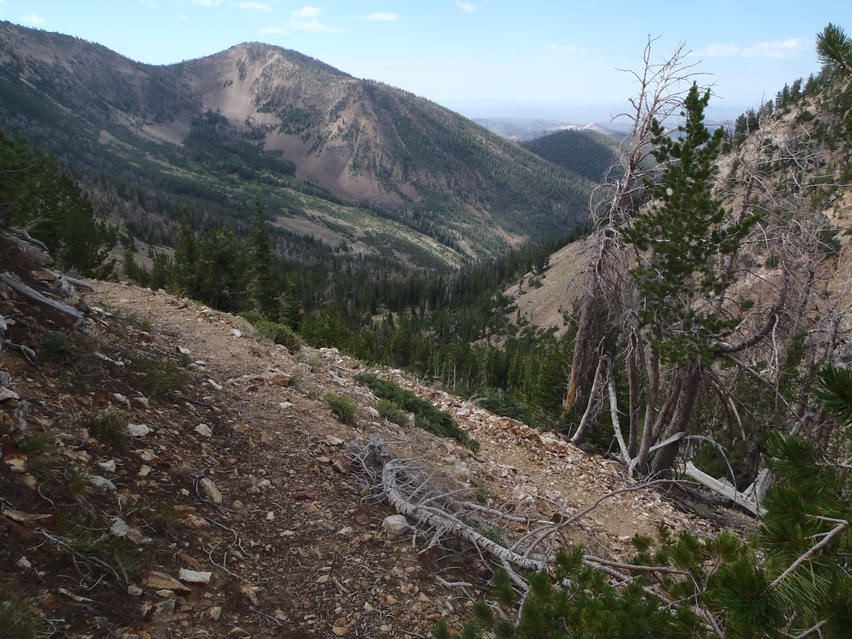
Day 2 was going to be a layover day at Jarbidge or Emerald Lake, but after getting freaked out by the scale of the place we didn't know if we could complete the loop we planned in the 5 days we had. We discovered early on that trail signs were kind of a joke and not to be depended upon for planning. Some were in kilometers and others weren't, most were in neatly piled pieces on the ground. It was actually pretty sad....like the forest service was a relic of the past, beaten into submission by ill politics, and these neat old routed signs were all that was left. Like the signs, the trails were in need of repair. Some were pretty scary with yawning exposure beneath a trail as wide as my boot. Such as the 018 as it dramatically lowered us into West Mary's River. It's plenty obvious that not many folks walk these trails, but for me that's part of the allure. The reality of being on our own sort of throbbed in the back of my mind the whole trip. Lots of times the trail would fizzle out and we'd spend hours following the maps topography and random elk trails. While ascending East Fork Jarbidge River, through a huge burn area, the trail didn't exist. We spent 5 hours to move a little over 2 miles. Breathing hard, ascending that valley, exhausted, but elated only the way that wilderness can reward after completing such a physical and mental task.
As we left Camp Creek I said "I hope were not still walking at dark, wishing we stayed here". Sure enough; we were. Everything after Camp Creek/Marys River Divide was trashed by sheep and water was way off trail. We walked into the waning moments of light when we found a small gravel beach in the head of Marys River Basin. It wasn't the prettiest backcountry campsite I've ever found, but since it was now dark; who could've cared, it was perfect. We made our salty gruel by headlamp, then drank cocoa and watched shooting stars until nearly midnight. We talked about the many hardships and dangers we overcame that day then sacked out on the coolness of the hard ground, deep in the Nevada Wilderness.
As anyone who's human knows; water rules everything. We ended up stomping out 15 miles because we couldn't find decent water. In hindsight we should've stayed at Camp Creek, but I'm glad that we were strong, and lucky, enough to deal with the unexpected nature of things.
The photos below of Marys River Peak give good perspective of the day. The first are from the north, the last from the south.
 |
| W. Marys R. from near Jarbidge L. |
 |
| Slide Rock Ridge and Marys R. Peak |
 |
| Jarbidge R. from near Jarbidge L. |
 |
| Emerald Lake |
 |
| N. face of Marys River Peak from near Emerald Lake |
 |
| Trail 020 NW of Slide Rock Ridge |
 |
| Trail 200 near head of E Fork Jarbidge River |
 |
| Trail 200 near head of E Fork Jarbidge River |
 |
| S. face of Marys River Peak from Trail 195 |


 |
| Kilometers? Miles? ...neither! |
 |
| Trail 193 |
|
| Top of E. Fork Jarbidge after a savage beating |
Day 3 (~7.5 miles)
Tr195 Marys River Basin to Marys R.
Tr018 Marys R. to W. Marys R.
Day 3 was a bit more chill. As we descended into Marys River the scenery really changed from high country alpine, to cottonwoods along the stream. We only had one 9,000' pass to ascend today, instead of three. It was on trail 018 from Marys River into West Marys River. We got really lucky the clouds were making for cooler temperatures because it was a treeless slog that sent the heart rate to the redline. We not-so-affectionately named it "Pissed Pass". Now, I like a good cardio workout as much as any, but as anyone who knows, sweating and breathing hard, hour after hour, can drive ones emotions and sanity to the limit, especially combined with the pain of a sore body, and the challenges of map reading. Lisa had her time on this pass. I had my time the day before after getting off trail, west of Slide Rock Ridge, and being thrown to the ground by clumsiness under the force of my 45lb. pack. I was pissed and didn't have a good reason, but Lisa was patient.
On the other side of Pissed Pass we rested in the shade of some spruce trees on a narrow little ledge of trail looking into an unnamed drainage and drank some sugary gatorade. We were mesmerized, and entertained by a crew of woodpeckers and soon noticed it was 4pm with a long descent into West Marys River still to do. West Marys River provided us with the prettiest campsite of the trip beside a pristine stream of clear mountain water. We filtered water then took a dip in the cold stream before making some dinner over the coals of a firepit where somebody unfortunately left trash. Early the next morning it rained for a few hours before daylight, but thankfully didn't snow on the next pass we had to cross.
 |
| Marys River Basin |
 |
| Marys River |
 |
| Remnant of a Marys River trail sign |
 |
| Lisa ascending Pissed Pass on the 018 |
 |
| Lisa surveying the labors of very big country |
 |
| Unnamed country between the Marys |
 |
| Happy and Strong |
 |
| Cooking our gruel...caveman style |
Day 4 (~7 miles)
Tr192 W. Marys R. to Jarbidge R.
Tr105 Jarbidge R. to Trailhead
We woke the last morning to a lovely rain on the tent that quickly gave way to a pot full of cowboy coffee by the fireside. We made scrambled eggs and resisted the trips inevitable end. We crossed one more big pass and stopped for a big lunch at the junction that signified the completion of a 34 mile loop.
 |
| West Marys River |
 |
| The climb out of W. Marys R. on the 192 |
 |
| Trail 192 near the pass |
 |
| Lisa dancing across the Jarbidge River |
It's always a good feeling to round a bend in the trail and see the ride home sitting there like a dutiful steed. The old blazer started like a new one and we rode into Jarbidge, Nv. (the town), listening to Ben Howard sing "The Old Pine".

In town we found a garage sale and a general feeling of merry-making about to commence around a wedding due to begin at 5pm. We went to the Outdoor Inn where we got some beers, sat on the porch, and made notes on the map. Since we chose to sit on the porch we were presented with a parade of ATV's going by, whose riders were stern faced, uniformly overweight, with patriotic flags mounted up respectfully in the dust of their machines. Before leaving, we signed the wall of the bar with the insignia that we usually leave in summit registers. As we left town and started up the 15% grade I thought of how different the world is between the town of Jarbidge and the high-country of the Jarbidge just a few, yet difficult, miles away.


No comments:
Post a Comment